
Stay 1 Night
9/28/2012
Elevation 2800ft-3460ft
Saint Mary's Wilderness is a designated wilderness area located on the west side of the blue ridge mountains. It has great trails, both out and backs and loops. These trails are yellow blazed but are not maintained by any forest services. Consistent hiking has kept these trails clear of debris and marked. This is a great area for day hikes or the over night camper. Animals are plentiful here but are very shy. Sightings of Bears and deer are common, although the day we hiked we did not encounter any but there was evidence of bear activity on Bald Mountain Trail.
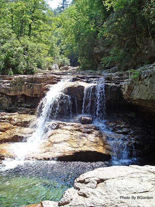
We did the Bald Mountain Trail located in Saint Mary's Wilderness. This is a great hike approximately 2.2 miles in length. We started the hike at mile post 23 off of the Blue Ridge Pkwy. There is a small parking lot that can fit about 5 cars comfortably and is perfect to set up a base camp if hiking and then camping is not your thing. The trail starts at the back of the parking lot with two options. To start on the Bald Mountain Trail you head to the right of the sign post marked-Bald Mountain Trail- if you head to the left you will start down Mine Bank Trail which will lead you to Saint Marys Trail. You can create a great loop hike by combining the two trails with Saint Mary's Trail and Big Levels Primitive Road. If a loop is created on the second leg of the hike (on Mine Bank Trail) there is a waterfall which will add another 5.5 miles to the hike.1
(Turn left downstream on the St. Mary's River Trail passing several campsites before reaching the intersection of the St. Mary's Falls Trail in 1.9 miles. Note: There is no camping permitted beyond this point. Turn right upstream fording St. Mary's River passing several swimming holes before there is a blowout on the trail in 0.4 miles. Follow the footpath to the left of the blowout that leads around the blockage back to the trail. At 0.6 miles from the last intersection the trail appears to end at a cliff about 15ft above the river. Climb down, re-ford the river, and climb up a steep bank. The falls are just ahead from this point. To continue, retrace your steps back to the intersection of the Mine Bank Creek and St. Mary's River Trails)

Overall this is a great hike. Not to difficult with plenty of campsites and water sources. Also nice because there are not a lot of people at one time on the trail but you do get the security of knowing that there are people on this beautiful trail.

Privacy 3/5-It was very secluded on the Friday night but when we got to the parking lot there were 3 other cars and a couple getting ready for the hike.
Difficulty 2/5- Not very difficult. Easy decline and easy incline. Loss in elevation 3300ft to 2700 ft
Views 0/5- If staying on Bald Mountain Trail it is a down hill hike into the valley with no views. If a loop is created using two other trails views are not plentiful but they are their. The waterfall is the main attraction.
Camping 5/5- I give a 5 of 5 because there are at least three different camping spots in two miles on Bald Mountain Trail and more along the other two trails to create a loop. Also the campsites are located next to a great water source and already have fire circles constructed which means less impact!
1Hiking
Upward; http://www.hikingupward.com/GWNF/StMarysWilderness/
No comments:
Post a Comment